1
Gunbarrel Gateway to the Lakes
Start/End: Intersection of Spine Road and Lookout Road, north side
Distance: 4.3 to 9 miles total
Time: 1.5 to 3 hours
Directions:
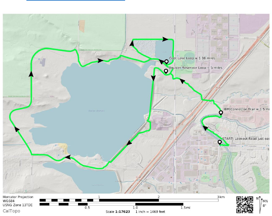
Get out for a beautiful early morning or late-afternoon hike from Gunbarrel to Coot Lake or
Boulder Reservoir (or both!) on this route, walking a total of 4.3 miles (around Coot Lake), 8
miles (around Boulder Reservoir), or 9 miles (both lake loops plus connector trail).
Start (or finish) with a takeout order from
Aperitivo or Ampersand Coffee Roasters in
the Gunbarrel shopping center on the north
side of Lookout Road (across from the King
Soopers plaza). Take your drink or snack and
head east on the sidewalk along Lookout
Road. Walk over the underpass tunnel and
make a sharp left onto the LoBo Trail
connector. Walk northwest along the paved
multi-use path that takes you behind houses
on the right and alongside the Boulder and
Whiterock Ditch on your left.
The paved path dead ends at the entrance to the Cottontail Trail. Follow the dirt trail around to
the east and cross the bridge over the ditch. Turn left (west) onto the IBM Connector trail.
Follow the trail under the railroad tracks and Highway 119. Cross 63rd Street at the crosswalk,
then choose your own adventure: go left to
hike about 5 miles around Boulder Reservoir
or right to explore the 1.38-mile Coot Lake
loop! The Gunbarrel connection is 1.5 miles
each way.